Wednesday, March 25, 2015

Flatland Highpointing in Indiana and Ohio

I have had a hobby now for several years to collect all of the 50 state highpoints, I move around a lot so as I move to a new area I usually look up the highpoints in the area and try to bag a few of them.  Last week I moved from Colorado Springs to Pittsburgh and along the way I figured I would break up the trip by picking up a few more highpoints.  I had already completed Colorado, Kansas and Missouri, so the others on the route were Illinios (which has some crazy restrictions) so that one was out, then finally Indiana and Ohio.   Both of these are relatively easy to find, pretty close to my route and wouldn't add a lot of time onto my already 22 hour drive. 

Hoosier Hill Indiana:
The Indiana Highpoint was really easy to get to, only a few minutes off of I-70.  There are a few small turns but nothing crazy.  Here are directions to the highpoint courtesy of Summitpost.org, however I just plugged "Hoosier Hill" into the GPS on my IPhone and it brought me right there.

Hoosier Hill is about a mile from the Ohio border. From Indianapolis, Indiana take I-70 East until you get to Richmond, Indiana. Take route 227 North up to Franklin Township. Go about 10 miles, and then take a left on Bethel Road, follow it for about a mile, and then take a right on Elliot Road, and head north for almost a mile. There is the short trail to the top that is well marked.
Hoosier Hill Signpost

The highpoint is found on a small rise just off the side of a farmers field in a small wooded area.  To help you find it there is a really convenient green sign posted right at the corner of the field.


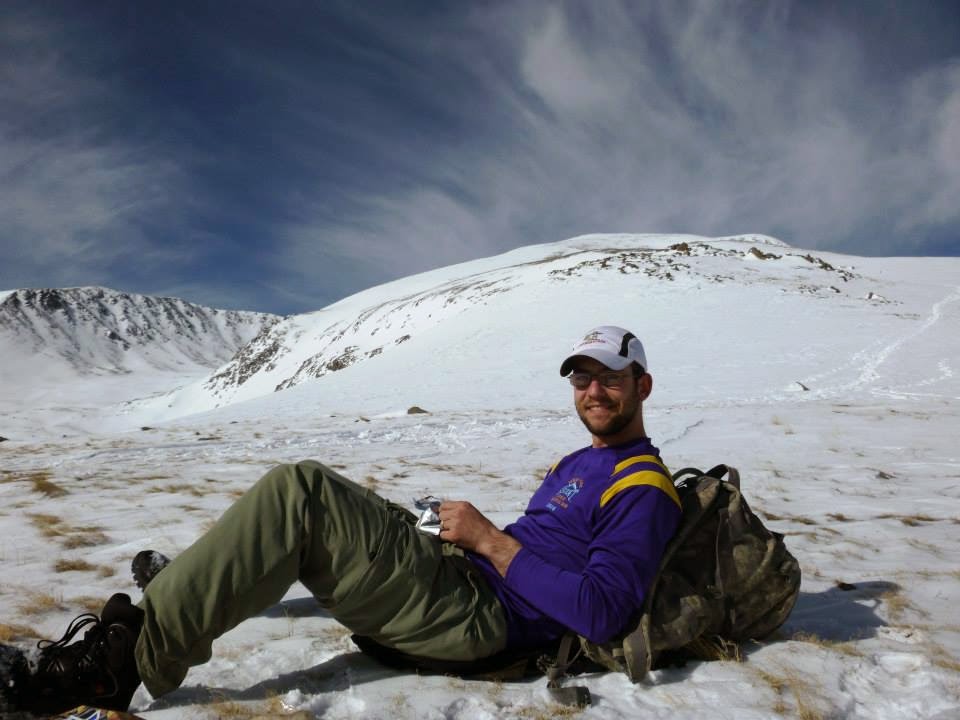
Me atop the "Summit" of Hoosier Hill
Once at the actual highpoint after a lofty summit attempt I stopped to take a few pictures and then hit the road again.  The highpoint was actually really nice considering it was such a small one.  there was a mailbox with a register (which I dutifully signed) and some cool information from highpointers on this highpoint and the highpoint club in general.  There were also a couple of picnic tables and an engraved stone marker marking the highpoint.  Pretty cool.


Highpointing information located
in the mailbox
Engraved stone marker marking the India


Campbell Hill Ohio:
The next stop along the way was the Ohio State highpoint of Campbell Hill.  This highpoint was another drive up and was located on the Campus of a school.  The bonus was that it was only about a two hour drive from Hoosier hill so they were both easily completed in the same day.  The only problem I had is that I started the morning in Missouri so I was burning daylight pretty quick and didn't want to get to Campbell hill after dark.  When I left the Indiana highpoint it was already 4 PM so I was cutting it close.  I pulled into Bellefontaine, Ohio right before 6 PM and I got a little lost trying to find the exact highpoint.  I had again plugged Campbell hill into my Iphone and it brought me near the hill but instead to a "Highpoint recycling center".  It took me a few minutes to find the campus of the Career Center, but once I found it it was easy to locate the highpoint.  Really once you hit the campus all you need to do is head uphill and look for a flagpole, you can't miss it.


This was another one of the "flatland Highpoints" but again despite being an unremarkable hill the town had done a pretty good job of celebrating the distinction as the state highpoint with a nice memorial to the fact.  There is a flagpole, a signpost and the US Army Corps of Engineers survey marker all prominently displayed.  Pretty cool if you ask me.  Again I didn't stick around long but grabbed a few pictures and kept going on my journey.  You can see the sun is on its way down which made photography difficult, but I think the photos actually came out kind of cool.  Enjoy!


 Feel free to leave any comments or ask any questions you might have.  Thanks for reading!

Monday, March 9, 2015

Winter Ascent of Mt Elbert- Trip Report

 This was my first winter ascent of a Colorado fourteener and it was an awesome trip.  I had been eyeing Mt Elbert for quite some time as it is on the list of the State Highpoints.  I have been collecting highpoints as a hobby since high school and ever since I moved to Colorado I have wanted to add the Colorado high point to my list.  Well, three years later and it was time to move out of Colorado and I still hadn't made the time to climb it.  I planned out the trip up the east ridge using  the South Mt Elbert trail and since it was winter we would need to use the trailhead at the bottom of the summer 4wd road.  I convinced a friend of mine to climb with me and thankfully he came along. I downloaded the .gpx files from 14ers.com and used my Garmin Foretrex 410 to navigate though most of the trail was pretty well defined.


We left Colorado Springs at about 5:00 and left the trailhead at 7:45.  The dashboard was reading 15 degrees when we stepped off so the snow was still packed well at from the trailhead all the way up the 4wd road.  Despite the temperatures we quickly heated up with hiking and dropped layers within the first 30 mins and climbed in long sleeve t-shirts and one other layer for the rest of the climb.

4wd Road leading to Trailhead


Elevation profile of the route...
Trailhead sign at top of 4wd road


 We continued over the small footbridge and uphill from there, the trail was pretty steep and slick but I put on my microspikes and had enough traction to make it up without too much trouble.  There had been quite a few people on the trail to pack down the snow so we didn't need snowshoes for a good portion of the climb.  The scenery was great as we plodded through the aspen grove and continued to climb.
Travis making his way through the Aspens
Footbridge
Eventually as we neared treeline the trees changed from aspens to pines and the snow got deeper.  I began to posthole quite a bit (up to my waist at one point) and we finally decided to put on the snowshoes which we wore for a while longer.   It was right about this time we passed a group of 5 from Texas who had traveled up for the weekend to climb Elbert.  They said they had stashed their snowshoes at the 4wd trailhead and were regretting it.  We continued on and didn't see them after that, they didn't summit that day, I hope they get a chance to get up there before they have to get back to Texas.

Travis at tree line
Snowshoes necessary above tree line
    We continued on snowshoes for a while longer and eventually made it to a small rocky outcropping  at 12,300' where we stopped to have an early lunch.  We were in no rush to the top so we took our time and after about 30 mins kept heading up.

Great spot for lunch right at about 12,300'


The snow was pretty stiff and windblown so we strapped the snowshoes back to our packs and kept climbing in the microspikes.  This served us well to the summit, the remainder of the climb alternated from stiff windblown snow to bare rock and we actually followed the summer trail which was still visible in sections to within about 1,000' of the summit.  At this point the well defined trail we were following from other climbers had branched out into many different approaches so we generally just kept heading "up" with minor course corrections looking at the waypoints on my Foretrex.

We actually spotted several groups of ptarmigans by nearly stepping on them, their camouflage is pretty impressive and their coos were an interesting way to break up the monotony of the climb up for a while.

Pretty cool little birds
The last few hundred feet of elevation consisted of  a thick snow cap and several false summits, by now the altitude had really started to catch up to me and it seemed like I needed to take a break every few steps.   As we were nearing the summit two other groups passed us on their way down but they were taking a slightly different track so we didn't talk much more than a few waves.  Finally we were in view of the summit and took the last few steps to the highest peak in Colorado.  We summited at 1:45 which gave us about 6 hours of climb time to the top. The views were spectacular and the feeling of completing this highpoint was incredible.  We stayed at the top long enough to snap a few pictures but clouds were starting to build so we didn't want to stay too long.

Summit pictures


  The descent was quick with nothing really to report except that the temperatures were starting to warm and thus the snow starting to melt.  At about 12,300 feet we stopped at the same spot we had lunch at on the way up and donned our snowshoes and needed them for the rest of the climb down.  As we got into treeline the snow really got soft and I was once again thankful for the snowshoes, the steeper sections were very slick and we took a few slips and falls but overall no major problems for the descent.  We made it back to the car just after 4:00 pm just in time to see the clouds really billowing over the summits.  The total trip took us 8 hours and 15 minutes with a distance of 11.4 miles and 5,409' of elevation gain. 

Below is a link to my Garmin adventure (built with garmin basecamp) with geotagged photos.  Enjoy!  Mt. Elbert Winter Ascent